Is First Cyclone of 2026 Forming in Bay of Bengal? Heavy Rains Alert in Tamil Nadu
By Lokmat Times Desk | Updated: January 9, 2026 09:19 IST2026-01-09T09:19:45+5:302026-01-09T09:19:58+5:30
Due to atmospheric circulation over the central equatorial Indian Ocean and the Bay of Bengal, a low-pressure area formed ...

Is First Cyclone of 2026 Forming in Bay of Bengal? Heavy Rains Alert in Tamil Nadu
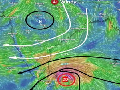
Due to atmospheric circulation over the central equatorial Indian Ocean and the Bay of Bengal, a low-pressure area formed over the southeast Bay of Bengal and the equatorial Indian Ocean. It will further intensify into a deep depression by 5.30 am on Friday, January 9 and has since strengthened further into a depression.
According to the India Meteorological Department (IMD), the system is likely to intensify further and may develop into the first cyclone of 2026. If it strengthens into a cyclone, heavy rainfall is expected in several parts of Tamil Nadu. The system is likely to cross the coast by today evening or night.
The deep depression over southwest Bay of Bengal moved nearly northwestwards with a speed of 10 kmph during past 6 hours, and lay centred at 2330 hours IST of yesterday, the 8th January, 2026 over the same region, near latitude 6.7°N and longitude 83.6°E, about 200 km… pic.twitter.com/sYfhVZVEs4
— India Meteorological Department (@Indiametdept) January 8, 2026
"The deep depression over southwest Bay of Bengal moved nearly northwestwards with a speed of 10 kmph during past 6 hours, and lay centred at 2330 hours IST of yesterday, the 8th January, 2026 over the same region, near latitude 6.7°N and longitude 83.6°E, about 200 km east-southeast of Pottuvil (Sri Lanka), 240 km east-southeast of Batticaloa (Sri Lanka), 280 km east-northeast of Hambantota (Sri Lanka), 330 km southeast of Trincomalee (Sri Lanka), 630 km southeast of Karaikal (Puducherry) and 800 km south-southeast of Chennai (Tamil Nadu). It is very likely to continue to move northwestwards and cross Sri Lanka coast between Pottuvil and Trincomalee around evening/night of 9th January 2026," IMD in its latest bulletine.
The deep depression is currently located about 860 km south-southeast of Chennai and is moving northwestwards at a speed of around 15 kmph. As of 8.30 am on January 8, it was positioned about 410 km east-southeast of Hambantota, 420 km east-southeast of Matale, 520 km southeast of Trincomalee in Sri Lanka, 810 km southeast of Karaikal and 980 km south-southeast of Chennai.
Also Read | Heavy rain forecast for TN on Jan 9-10 as low-pressure area forms over Bay of Bengal.
The system is expected to move west-northwestwards over the southwest Bay of Bengal during the next 36 hours and cross the Sri Lankan coast between Hambantota and Kalmunai on the evening or night of January 9. Meanwhile, another atmospheric low-pressure area is prevailing over the south Kerala coast and the adjoining southeast Arabian Sea.
IMD's Weekly Weather Forecast
Rainfall forecast for Tamil Nadu
Light to moderate rain is likely at a few places in coastal Tamil Nadu, Puducherry and Karaikal, while interior Tamil Nadu is expected to remain dry. On January 9, heavy to very heavy rain is likely at a few places in Tiruvarur and Nagapattinam districts and in Karaikal. Heavy rain is also expected at isolated places in Ramanathapuram, Pudukkottai, Thanjavur and Mayiladuthurai.
On January 10, heavy to very heavy rain is likely at isolated places in Tiruvarur, Nagapattinam, Mayiladuthurai and Cuddalore districts, as well as in Puducherry and Karaikal. Heavy rain is also expected in Chengalpattu, Villupuram, Kallakurichi, Ariyalur, Thanjavur, Pudukkottai and Ramanathapuram districts.
Warning to Fishermen
From January 8 to January 10, harsh weather with wind speeds of 45–55 kmph, gusting up to 65 kmph, is likely along the Tamil Nadu coast, the Gulf of Mannar and the Kumari sea areas. Fishermen are advised not to venture into these regions.
Open in app