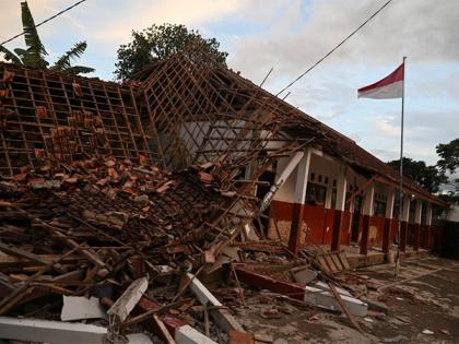
Earthquake of magnitude 6.3 rattles Indonesia
By ANI | Updated: August 12, 2025 16:09 IST2025-08-12T16:03:17+5:302025-08-12T16:09:56+5:30
Jakarta [Indonesia], August 12 : An earthquake of magnitude 6.3 rattled Indonesia on Tuesday, a statement by the National ...

Earthquake of magnitude 6.3 rattles Indonesia
Jakarta [Indonesia], August 12 : An earthquake of magnitude 6.3 rattled Indonesia on Tuesday, a statement by the National Center for Seismology (NCS) said.
As per the statement, the earthquake took place at a depth of 39km.
In a post on X, the NCS said, "EQ of M: 6.3, On: 12/08/2025 13:54:27 IST, Lat: 2.09 S, Long: 138.81 E, Depth: 39 Km, Location: West Papua Indonesia."
{{{{twitter_post_id####EQ of M: 6.3, On: 12/08/2025 13:54:27 IST, Lat: 2.09 S, Long: 138.81 E, Depth: 39 Km, Location: West Papua Indonesia.
For more information Download the BhooKamp App https://t.co/5gCOtjcVGs @DrJitendraSingh @OfficeOfDrJS @Ravi_MoES @Dr_Mishra1966 @ndmaindia pic.twitter.com/J5yuonUG2a
— National Center for Seismology (@NCS_Earthquake) August 12, 2025
Earlier on August 7, another earthquake of magnitude 4.9 on the Richter Scale occurred at a depth of 106km.
In a post on X, the NCS said, "EQ of M: 4.9, On: 07/08/2025 20:59:00 IST, Lat: 1.03 N, Long: 98.80 E, Depth: 106 Km, Location: Northern Sumatra, Indonesia."
}}}}EQ of M: 4.9, On: 07/08/2025 20:59:00 IST, Lat: 1.03 N, Long: 98.80 E, Depth: 106 Km, Location: Northern Sumatra, Indonesia.
For more information Download the BhooKamp App https://t.co/5gCOtjdtw0 @DrJitendraSingh @OfficeOfDrJS @Ravi_MoES @Dr_Mishra1966 @ndmaindia pic.twitter.com/5yTKYrczVv
— National Center for Seismology (@NCS_Earthquake) August 7, 2025
Indonesia is located between two major tectonic plates, namely, the Australian Plate and the newly separated Sunda Plate.
The tectonics of Indonesia is very complex, as it is a meeting point of several tectonic plates. Indonesia is located between two continental plates: the Sahul Shelf and the Sunda Plate, and between two oceanic plates: the Pacific Plate and the Philippine Sea Plate.
The subduction of the Indian Plate beneath the Sunda Plate formed the volcanic arc in western Indonesia, one of the most seismically active areas on the planet, with a long history of powerful eruptions and earthquakes.
This chain of active volcanoes formed Sumatra, Java, Bali, and the Lesser Sunda Islands, most of which, particularly Java and Bali, emerged within the last 2-3 million years. The Pacific and Sahul plate movements controlled the tectonics of the eastern portion of Indonesia.
Subduction occurs along Southeastern Sumatra and West Java. Sumatra is more active in recent years despite being in the same subduction margin. The reason for the lack of frequent seismic activity over West Java is a problem of time frame and not of tectonic activity. While it may only take a hundred years for a large-scale earthquake to occur off the coast of Sumatra, it may take roughly 500 years off the coast of western Java.
Disclaimer: This post has been auto-published from an agency feed without any modifications to the text and has not been reviewed by an editor
Open in app