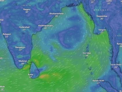
Cyclone Shakti Live Tracker Map: Strong Winds Lash West Bengal and Andaman As Cyclonic Storm Likely to Landfall on May 24
By Lokmat English Desk | Updated: May 14, 2025 12:29 IST2025-05-14T12:28:11+5:302025-05-14T12:29:55+5:30
Heavy rains and strong winds have been reported in various parts of West Bengal since Wednesday morning, May 14. ...

Cyclone Shakti Live Tracker Map: Strong Winds Lash West Bengal and Andaman As Cyclonic Storm Likely to Landfall on May 24
Heavy rains and strong winds have been reported in various parts of West Bengal since Wednesday morning, May 14. Flooding has occurred, trees have been uprooted in several areas, and the power supply has been disrupted. Videos on social media show knee-deep waterlogging in many parts of the state due to heavy rainfall amid Cyclone Shakti, which is likely to make landfall between May 24 and 28.
Weather experts are expressing concern over the possible formation of Cyclone 'Shakti' in the Andaman Sea. If the system intensifies, there is potential for widespread damage in coastal regions. According to the India Meteorological Department (IMD), a depression may gradually gain strength and evolve into a cyclone. Coastal state administrations have been instructed to remain alert, and fishermen have been advised not to venture into the deep sea.
Rainfall in West Bengal
Jalpaiguri, West Bengal: Heavy rain and thunderstorms disrupted in Jalpaiguri from early morning, uprooting trees and causing power outages. The storm brought relief after days of intense heat pic.twitter.com/R2EFr43QyI
— IANS (@ians_india) May 14, 2025
Also Read | Cyclone Shakti: Early Monsoon as Cyclonic Storm Brews Over Andaman Sea; Likely to Landfall On These Dates.
However, you can track the live status of Cyclonic Storm Shakti on Windy.com and Zoom. Earth via satellite map, as both portals use live tracking technology for weather updates and cyclonic circulations, showing forecasts of cyclones and possible hurricanes.
Check Cyclone Shakti Live Tracker Map on Windy
Check live satellite map of India coast on Windy where cyclonic circulations can be seen, which is predicted to form a cyclone by May 23 and likely to make Landfall on May 24 between Odisha and West Bengal, which is likely to bring heavy rainfall and thunderstorms with high winds.
Meanwhile, the IMD stated that the southwest monsoon has already reached parts of the South Bay of Bengal, South Andaman Sea, Nicobar Islands, and North Andaman Sea. It is expected to advance further into more parts of the South Arabian Sea, Maldives, the Comorin region, the remaining parts of the Andaman Sea, the entire Andaman and Nicobar Islands, and parts of the central Bay of Bengal over the next three to four days.
The IMD has predicted that the monsoon will reach Kerala by May 27, earlier than the usual date of June 1. Regional weather experts said an elevated air circulation over the Andaman Sea is likely to intensify into a depression between May 16 and 22. According to forecasts, this system may strengthen into a cyclone—likely to be named 'Shakti'—between May 23 and 28.
"An elevated air circulation system is currently located over the Andaman Sea at an altitude of 1.5 km to 7.6 km and is inclined southwestwards with increasing height," the IMD stated in a press release on Tuesday.
IMD has issued a yellow alert for several districts in Karnataka. Pre-monsoon rains are expected to persist in the region until May 16. According to forecasts for Kolkata, the sky will remain partly cloudy on Wednesday, with light to moderate rain and thunderstorms expected.
Open in app