TN to procure DGCA-certified Agri, survey drones to boost farming, land mapping
By IANS | Updated: November 13, 2025 09:25 IST2025-11-13T09:24:28+5:302025-11-13T09:25:19+5:30
Chennai, Nov 13 In a significant move to modernise farming practices and strengthen land-survey operations, the Tamil Nadu ...

TN to procure DGCA-certified Agri, survey drones to boost farming, land mapping
Chennai, Nov 13 In a significant move to modernise farming practices and strengthen land-survey operations, the Tamil Nadu Unmanned Aerial Vehicles Corporation (TNUAVC), functioning under the Higher Education Department, has begun the process to procure DGCA-certified agricultural drones and survey-grade drones.
A senior official from the department confirmed that both categories of drones have successfully undergone rigorous testing by the Directorate General of Civil Aviation (DGCA), meeting all safety, performance, and operational standards.
“The DGCA type-certification is mandatory for any drone intended for formal use. It ensures safety compliance and also makes them eligible for government subsidies and institutional loans,” the official said.
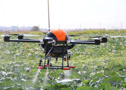
TNUAVC has floated tenders for both types of drones. According to the official, the lightweight agricultural drones -- constructed using durable carbon fibre -- are engineered to offer end-to-end technological solutions for farmers.
These drones will come with precise spray mechanisms, customised nozzles, and firm anti-interference antennas to ensure seamless field operations. They are also equipped with intelligent safety features such as early-warning alerts and automatic return-to-home functions.
“The drones can accurately spray any pesticide depending on plant growth patterns and field density. They are also easy to assemble and will be supplied with a flight-crash warranty,” he added.
The state government plans to procure around 50 such agri drones. Alongside these, TNUAVC will also acquire survey drones developed for highly accurate aerial mapping of land and other required areas.
These drones will be fitted with advanced imaging systems capable of capturing clear, non-pixelated photographs and high-quality video footage, ensuring improved land records, planning, and monitoring.
The official said the survey drones are built with strong data-security features that automatically block unrecognised users from accessing or receiving information. They are also designed to operate in varied terrains and withstand extreme hot and cold temperatures, keeping in mind Tamil Nadu’s climatic variations.
Disclaimer: This post has been auto-published from an agency feed without any modifications to the text and has not been reviewed by an editor
Open in app