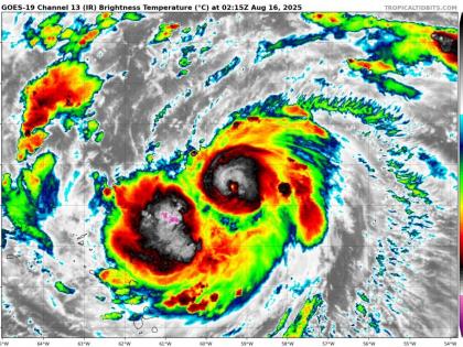
Hurricane Erin Enters Into Category 2 Storm With Maximum Winds of 100 mph, Heavy Rainfall Over Caribbean Islands Likely
By Lokmat Times Desk | Updated: August 16, 2025 09:44 IST2025-08-16T09:41:42+5:302025-08-16T09:44:54+5:30
The cyclonic storm Hurricane Erin has strengthened to a Category 2 on Friday evening, August 15, with winds up ...

Hurricane Erin Enters Into Category 2 Storm With Maximum Winds of 100 mph, Heavy Rainfall Over Caribbean Islands Likely
The cyclonic storm Hurricane Erin has strengthened to a Category 2 on Friday evening, August 15, with winds up to 100 miles per hour (mph) with a minimum pressure of 979 millibars, according to the US National Weather Agency. The story is now moving through warmer water and likely to become Category 4 Hurricane this weekend with winds up to 145 mph. The diameter of the storm to be over 650 miles.
As per the latest forecast, heavy rainfall is likely to occur on Saturday and Sunday in the Caribbean islands, including the Leeward, Virgin, and Puerto Rico islands. There will be considerable flash and urban flooding, along with landslides or mudslides. Erin will pass through the north Leeward Islands.
Hurricane Erin has intensified into a Category 2 storm with maximum sustained winds of 100 mph (160 km/h), the U.S. National Hurricane Center reported late Friday. pic.twitter.com/RpmZ6Cst9e
— AZ Intel (@AZ_Intel_) August 16, 2025
Hurricane Erin directly impact on Bahamas and along the east coast of the US as significant risk of dangerous surf and rip currents along western Atlantic beaches next week.
According to the Hurricane National Centre, Erin is currently about 400 km east-northeast of Angulla with a maximum speed of 160 kmph and intensifying further into a cyclonic storm. As per the 5 pm forecast, winds are moving 75 mph, making it a Category 1 storm.
Hurricane Erin became the first hurricane in the 2025 Atlantic basin on Friday morning. The storm is expected to continue moving west-northward over the next few days. According to Yahoo News, Erin is likely to move just north of the northern Lesser Antilles, the Virgin Islands, and Puerto Rico on Saturday and Sunday.
Erin is likely to stay well east of Florida as it makes a northward turn. The east coast of the state will likely witness major currents and high tides early next week. Dry air will also likely push into Florida, reducing storm chances for the middle of next week.
Open in app