Thane: TMC Launches First-Ever Flood Risk Management Action Plan for 2024 - Details Inside
By Nirmeeti Patole | Updated: June 22, 2024 17:06 IST2024-06-22T17:04:08+5:302024-06-22T17:06:14+5:30
The Thane Municipal Corporation (TMC) has launched its first-ever Flood Risk Management Action Plan for 2024, marking a significant ...

Thane: TMC Launches First-Ever Flood Risk Management Action Plan for 2024 - Details Inside
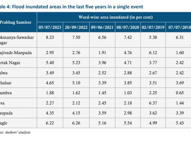
The Thane Municipal Corporation (TMC) has launched its first-ever Flood Risk Management Action Plan for 2024, marking a significant step towards urban resilience. While the plan showcases proactive measures, it also highlights critical challenges. The Majiwada-Manpada administrative block faces the highest flood risk, followed by Diva and Naupada in the high-risk category. The Vartak Nagar block is at the lowest risk for urban floods. The plan reveals that currently, drains are not being cleaned and desilted enough. It also highlights that trenching and desilting of the nullahs are done on a small scale. Despite these challenges, TMC Commissioner Saurabh Rao, who launched the plan today, has expressed confidence that this comprehensive action plan will enhance the corporation's capacity for good governance and improve the city's flood preparedness.

Developed in collaboration with the state government and the Council on Energy, Environment, and Water (CEEW), the plan aims to prioritize flood-prone areas and enhance rapid response capabilities. For this, rainfall data from the past 52 years, socio-economic factors, and satellite information to identify flood risks at the ward level have been analyzed. Nitin Bassi, Senior Program Officer of CEEW, stated that this preparation is important as the Indian Meteorological Department has predicted above-average rainfall this year.
According to Thane city's urban flood risk index, Majiwada-Manpada emerged as the most at-risk area, branded with a 'Very High Risk' label. This densely populated zone faces significant hazards from historical flood patterns and inundated areas. Weak stormwater network coverage and the high proportion of below-poverty-line (BPL) households further amplify its vulnerability.

Read Also | Thane School Roof Collapse: 2 Injured as Roof Sheet Falls on Nearby Houses (Watch Video)
Recommendations:
The plan calls for the strategic placement of automatic weather stations (AWS) in high-risk areas. Currently, Majiwada-Manpada and Diva each have one AWS, while Naupada has none. The plan recommends increasing these numbers to meet World Meteorological Organization norms. As per the WMO norms, there should be at least one AWS for every 10–20 sq km (IMD n.d.).
Complete pre-monsoon desilting of all major drains by March 31 each year. Additionally, schedule the periodicity of cleaning drains based on the local conditions.
Do not allow waste removed from the major and minor drains to remain outside the drain for drying. Dispose of waste promptly. Replace aging stormwater and sewerage systems on an urgent basis.
Incorporate the concept of rain gardens when planning public parks and on-site stormwater management for larger colonies and sites.
Under the Thane Urban Flood Alert Network (TUFAN), early warning systems based on the Internet of Things (IoT) are installed at six locations. It includes four ultrasonic and two radar-based water level sensors and one AWS. Install similar IoT-based early warning systems on the nullahs that are in close proximity to flood hotspots identified by the Stormwater Department and in this action plan.
Mill the existing layers of the road during relevelling works or strengthening overlay works to prevent an increase in road levels.
Study Indicates Drainage Capacity Insufficient for Heavy Rainfall:
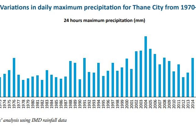
Thane is a city that is rapidly expanding its urban landscape, resulting in significant changes in land use. The 24-hour maximum precipitation over the last 52 years ranged from 72 mm to 267 mm, representing a high temporal variability; the coefficient of variation was 32 percent. Such a high variation in precipitation presents a challenge to the city administration, especially during years with high rainfall that can potentially cause urban flooding. The city's current drainage capacity of 16.73 cubic meters per second per square kilometer is insufficient for a 10-year return period rainfall event. To address this, the TMC plans to upgrade its stormwater network by adding 131 km under the Integrated Nullah Development Programme, aiming to handle once-in-a-decade rainfall events effectively.