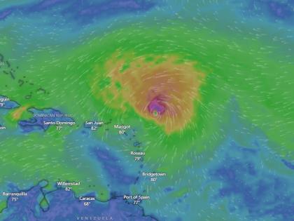
Hurricane Erin Live Tracker Map on Windy: Cyclonic Storm Likely to Intensify Into Category 4 on August 17; Check Real-Time Status
By Lokmat Times Desk | Updated: August 16, 2025 10:40 IST2025-08-16T10:40:18+5:302025-08-16T10:40:45+5:30
According to the US National Hurricane Centre, Hurricane Erin is forecasted to intensify into a Category 4 cyclonic storm ...

Hurricane Erin Live Tracker Map on Windy: Cyclonic Storm Likely to Intensify Into Category 4 on August 17; Check Real-Time Status
According to the US National Hurricane Centre, Hurricane Erin is forecasted to intensify into a Category 4 cyclonic storm over the weekend (August 16 and 17). The storm is currently travelling at a speed of 100 mph west-northwestward across the Atlantic and is likely to hit the Caribbean Islands, including Puerto Rico and the Virgin Islands.
Hurricane Erin became the first hurricane of the 2025 Atlantic hurricane season on Friday. The cyclonic storm likely influence heavy rainfall with gusty winds. A significant rip current threat is expected in the week ahead from Florida to Massachusetts.
Erin moved west-northwest into warmer waters, which, in tandem with low shear, will turn the storm into a dangerous hurricane this weekend as its center tracks north of the northern Leeward Islands, Virgin Islands, and Puerto Rico.
Hurricane Erin Live Tracker
Track Hurricane Erin through satellite as Widy.com gives live tracking updates and the movement of the cyclonic storm so that one can stay alert. To get a real-time update on Erin, check the live map, which gives you the current position of the Hurricane.
In the next 48 hours, Erin will bring breezy and rainy conditions to St. Martin, St. Barts, Anguilla, and Barbuda. It will pass near or north of the Leeward Islands on Saturday and can bring rainfall up to 6 inches. By Sunday morning (August 17), the hurricane will intensify into a Category 3 storm with winds up to 125 mph and could grow further into a Category 4 storm by evening with gusts reaching 140 mph.
Next week, Erin will continue to move northwest, staying east of the Bahamas. Life-threatening high tides still expected to reach the coast from August 20 to August 27, according to ABC News. Threat to the property near the coast as tides with strong currents will likely hit the coast along North Carolina's Outer Banks.
The Outer Banks and other parts of North Carolina could see waves of 8 to 12 feet, with other areas of South Carolina and Virginia possibly seeing waves reaching 6 feet next week.
Open in app