Work on Hyderabad Old City Metro Rail corridor gathers pace
By IANS | Updated: September 7, 2025 21:20 IST2025-09-07T21:16:30+5:302025-09-07T21:20:07+5:30
Hyderabad, Sep 7 The preparatory work to provide Metro Rail connectivity to the Old City of Hyderabad is ...

Work on Hyderabad Old City Metro Rail corridor gathers pace
Hyderabad, Sep 7 The preparatory work to provide Metro Rail connectivity to the Old City of Hyderabad is gathering pace, Hyderabad Airport Metro Limited (HAML) Managing Director N.V.S. Reddy announced on Sunday.
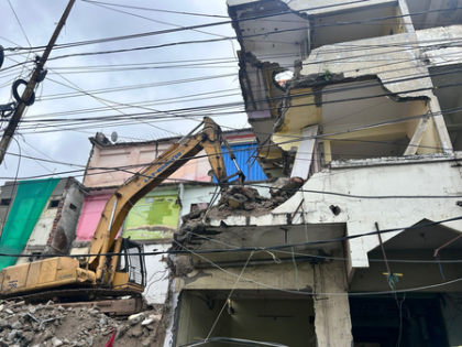
He stated that the land acquisition and demolition of affected properties in the 7.5 km Old City Metro Corridor have reached a crucial stage, with the required Right of Way (RoW) being almost available now.
On the directions of Chief Minister A. Revanth Reddy, the Metro expansion works are being carried out at a rapid pace. The MD affirmed that every effort is being made to realise the long-cherished dream of Metro Rail connectivity for the people of the Old City.
Although the initial estimate of affected properties stood at 1,100, innovative engineering solutions have brought the number down to 886. Over 550 demolitions have already been completed, and work is underway to clear the remaining structures.
He revealed that compensation amounting to Rs 433 crore has been disbursed to property owners so far.
Despite challenges such as rain, festivals, and Muharram, the works have progressed smoothly without causing inconvenience to local residents. Complex electrical cable removals posed hurdles, but these have been successfully overcome, the MD added.
Reddy said that preparatory works for Metro pillars and station construction are in full swing. Focus areas include differential GPS (DGPS) surveys for precision mapping; identification and relocation of underground utilities; soil testing and geotechnical analysis; and protection of sensitive heritage structures along the alignment
Unlike conventional surveys, DGPS offers high-accuracy digital mapping. Data from DGPS has been integrated with previous drone surveys to accelerate implementation. The corridor has been divided into segments with control points established for accurate positioning using high-precision GNSS (Global Navigation Satellite System) receivers. These satellite-based signals are vital for survey and mapping operations, the MD said.
Reddy emphasised the importance of identifying and diverting underground obstacles at pillar locations. Given the age of the roads, numerous water, sewage, stormwater, electricity, and telecom lines exist beneath. As per the master plan, the road is being widened to 100 feet, necessitating demolition of impacted properties.
Agencies, including Hyderabad Water Board, GHMC, TGSPDCL, and BSNL, are collaborating to relocate utilities. Ground Penetrating Radar (GPR) surveys are being conducted to detect subsurface structures and materials.
Soil strength and groundwater conditions are being assessed through geotechnical investigations to ensure the Metro foundations can bear the load. These tests are mandatory before the construction begins.
The alignment passes through several sensitive structures, which have been identified, and the alignment has been adjusted accordingly. Pillar locations are being marked based on this refined alignment, with milestone markers placed every 100 meters to guide construction, the MD added.
Disclaimer: This post has been auto-published from an agency feed without any modifications to the text and has not been reviewed by an editor
Open in app